

Tailing and waste dump seepage evaluation and remediation
/
Current and historical mining activities have a seepage and waste-dumps legacy that are the concern for mining companies, population and regulatory authorities.
Old waste-dumps have not been regulated and most of the old tailings have been deposited in soils without covering. Tailing deposits and waste-dumps should be analyzed in a particular way because of the ground, instalation details, mineralized body geology, mined type, weather and other parameters.
Recent mining activities count with major engineering in waste-dumps and tailing deposit instalations, as well as better monitoring evaluation seepage. However, there is still a seepage risk coming from old and new waste-dumps and their transport constituties a potential environmental issue.
Conceptual Framework
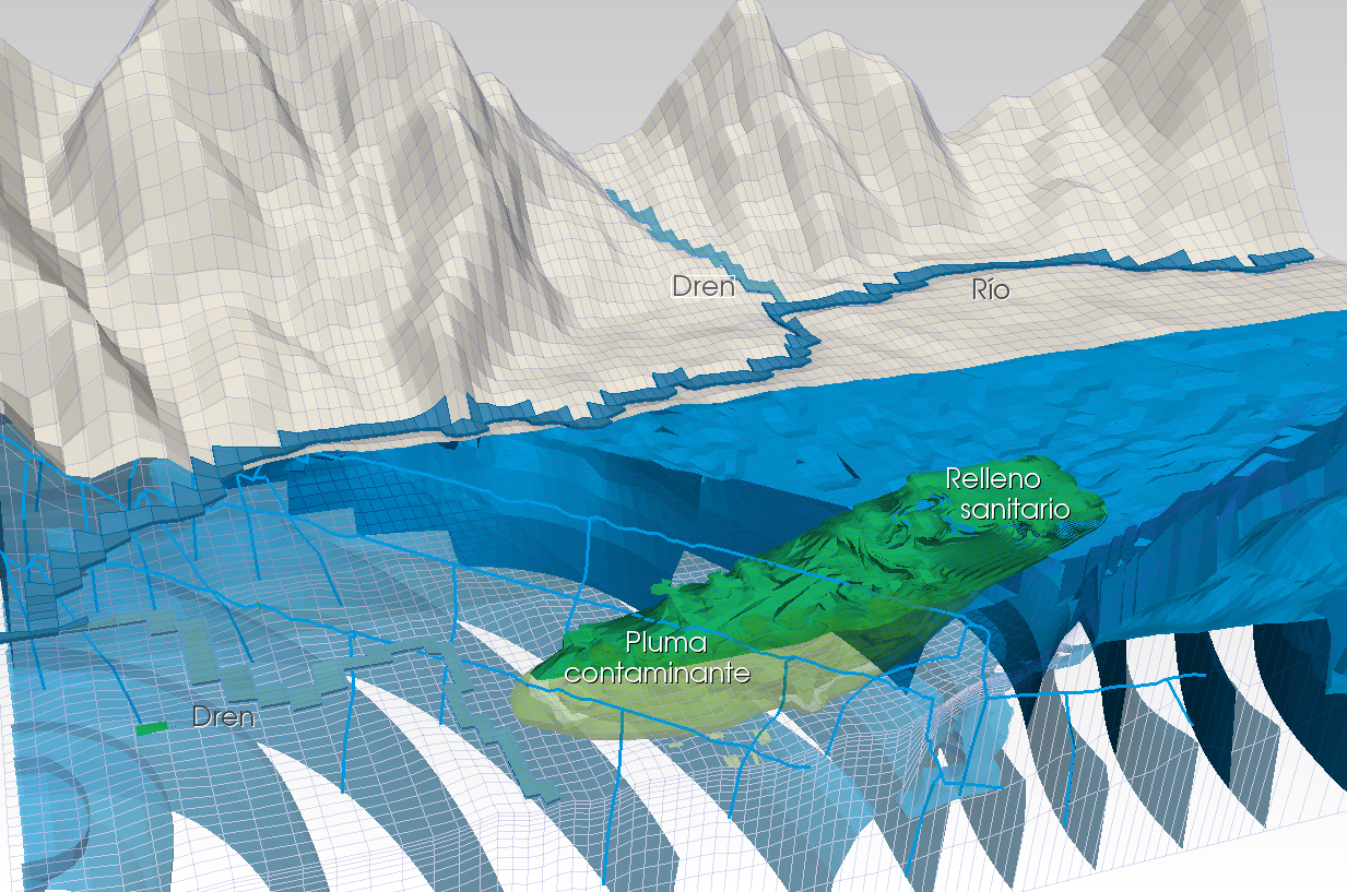
Precipitation and regional groundwater flow interact with tailing deposits and waste-dumps producing leachates, that is contaminated water with heavy metals and other components that are in contact as it moves through the deposit. Leachate leaks pollute groundwater under tailing deposits and waste-dumps and form the “contamination plume”.
The groundwater flow causes leachates plume to extend outside waste-dumps and tailing deposits, in some cases, a hundred of meters.

Objectives
The proposal has as objective to completly understand the filtration process and extension of the contamination plume and its implementation for more efficient remediation and isolation measures of the contamination plume away from superficial and groundwater.
Remediation measures are intended to minimize pollutants migration in groundwater. Calculations and predictions are focused on the design of a low cost remediation system and easy instalation with continuous monitoring to measure effectiveness.
Working methodology
The methodology provided by Gidahatari includes all relevant aspects to the evaluation and remediation of the tailing deposits and waste-dumps filtration, from the characterization to the continuous monitoring of filtration and efectiveness of the remediation systems.

1. Field investigation
Initially, we performed fieldwork to identify the current tailing situation in the terrain. This work consists in the evaluation of soil profiles in pits and identification of water bodies surrounding and their status.
Take chemical samples of the main water bodies, natural springs, tailing lakes and the upwelling of leachates.
Initial and final topography data recopilation, tailing deposits and waste-dumps instalation details, interception system data, meteorology, rainfall, flow records and water chemestry.
2. Initial hydrogeochemistry characterization and general modeling
With the hydrological and chemistry information, the conceptual model is built and boundary conditions of the general numerical model are defined.
The general numerical model is built with average values of hydraulic conductivity. Based on the water cycle characterization, referencial recharge values and evapotranspiration are incorporated to the model. Numerical modeling work has water flow and mass transport.
Model results are used to determine the location and depths of monitored wells.

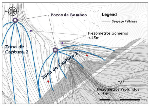
3. Piezometer instalation and instrumentation, sampling and hydraulic test
With the information provided by the general modeling, observation wells of 2” shallow (< 15 m) and deep (> 15 m) are installed. Relevant hydrogeochemical samples are taken for contaminant plumes identification.

Piezometers are instrumented with authomatic recorders of level and electrical conductivity. Collected data is used for the pumping test and the remediation measures monitoring.
Inside the drilled holes, 4" wells are included for the pumping test. Durability of the pumping test is considered important because the result contemplates a better answer of the aquifer and is a fundamental part in the calibration of the refined numerical model.
4. Refined numerical modeling
The general numerical model is refined with drilling logins, piezometric information, hydrogeochemistry results and the pumping test hydraulic parameter values. Refinement includes a better discretization of the quaternary layer and weathered rock under tailing deposits and waste-dumps.
Refined numerical modeling is equally mass and transport. Numerical model calibration is performed with piezometric levels and concentrations of heavy metal values observed.
Also, a quantitative analysis of the mechanisms of natural attenuation, precipitation and absorption of metal in suspension is performed.
Geology site can represent complexities in characterizing the contaminat plume due to the presence of fine layers inside the quaternary material, so the numerical modeling should represent this behavior with a suitable element discretization and hydraulic parameters.
5. Remediation measures simulation
With the calibrated model, remedial measures are proposed, these can be:
- Pumping wells
- Trenches of remediation
- Vertical drains
- Coverages
- Impermeable barriers with reactive barriers
Several alternatives of remediation will be simulated with the objective of finding the most consistent solution, of easy implementation, with low cost and less operation time.
6. Remediation measures implementation and monitoring
Conceptualized remedial measures are implemented in the field, and the monotoring of levels and concentrations in the piezometric network installed is done. Collected data is compared with predicted and, if necessary, an adjustment of remedial measures is defined


