How to georeference a image/raster with Python and Rasterio - Tutorial
/
Georeferencing an image/raster is the process of spatially locating an image so that each pixel is associated with a position. This process is widely known in QGIS with its Georeferencer plugin, but it can also be carried out using Python and Rasterio.
Georeferencing in Python has the advantage that it can be performed repeatedly without the need to define control points each time. It also allows you to add/remove control points and observe the impact on the transformation array. This tutorial demonstrates the complete georeferencing process of a national map using 3 points whose pixel coordinates have been extracted from the Paint utility in Windows. The tutorial also exports the raster while assigning a reference system.
Tutorial
#import required libraries
import rasterio
import matplotlib.pyplot as plt
from rasterio.plot import show
#open ungeoreferenced raster
unRefRaster = rasterio.open('data/Peligros_Geologicos.jpg')
unRefRasterC:\Users\saulm\anaconda3\Lib\site-packages\rasterio\__init__.py:317: NotGeoreferencedWarning: Dataset has no geotransform, gcps, or rpcs. The identity matrix will be returned.
dataset = DatasetReader(path, driver=driver, sharing=sharing, **kwargs)
<open DatasetReader name='data/Peligros_Geologicos.jpg' mode='r'>#show raster band values
unRefRaster.read(1)array([[255, 255, 255, ..., 255, 255, 255],
[255, 255, 255, ..., 255, 255, 255],
[255, 255, 255, ..., 255, 255, 255],
...,
[255, 255, 255, ..., 255, 255, 255],
[255, 255, 255, ..., 255, 255, 255],
[255, 255, 255, ..., 255, 255, 255]], dtype=uint8)#show raster
show(unRefRaster)
#show raster shape
unRefRaster.read(1).shape
(4133, 2922)Insert control points from coordinates captured in paint
Control point 1

point1 = rasterio.control.GroundControlPoint(row=368, col=190, x=-81, y=-1)
point1
GroundControlPoint(row=368, col=190, x=-81, y=-1, id='5a920799-66fd-469b-b8f5-8ad0f50194dd')Control point 2

point2 = rasterio.control.GroundControlPoint(row=3497, col=239, x=-81, y=-16)
point2
GroundControlPoint(row=3497, col=239, x=-81, y=-16, id='e74eee05-5a73-4632-a863-cf80dd0150b3')Control point 3

point3 = rasterio.control.GroundControlPoint(row=3706, col=2645, x=-69, y=-17)
point3
GroundControlPoint(row=3706, col=2645, x=-69, y=-17, id='75f9378c-a918-4a45-a7f8-7f662578e132')#list of selected gcps
points = [point1, point2, point3]
points[GroundControlPoint(row=368, col=190, x=-81, y=-1, id='5a920799-66fd-469b-b8f5-8ad0f50194dd'),
GroundControlPoint(row=3497, col=239, x=-81, y=-16, id='e74eee05-5a73-4632-a863-cf80dd0150b3'),
GroundControlPoint(row=3706, col=2645, x=-69, y=-17, id='75f9378c-a918-4a45-a7f8-7f662578e132')]#get transformation array from points
transformation = rasterio.transform.from_gcps(points)
transformationAffine(0.004994325053839821, -7.821090688339848e-05, -81.92014014649648,
7.980704784024951e-07, -0.00479387635201452, 0.7639948641504404)#define output raster
outputPath = 'data/georefRaster.tif'#create raster and write bands
with rasterio.open(
outputPath,
'w',
driver='GTiff',
height=unRefRaster.read(1).shape[0],
width=unRefRaster.read(1).shape[1],
count=3,
dtype=unRefRaster.read(1).dtype,
crs=rasterio.crs.CRS.from_epsg(4326),
transform=transformation,
) as dst:
dst.write(unRefRaster.read(1), 1)
dst.write(unRefRaster.read(2), 2)
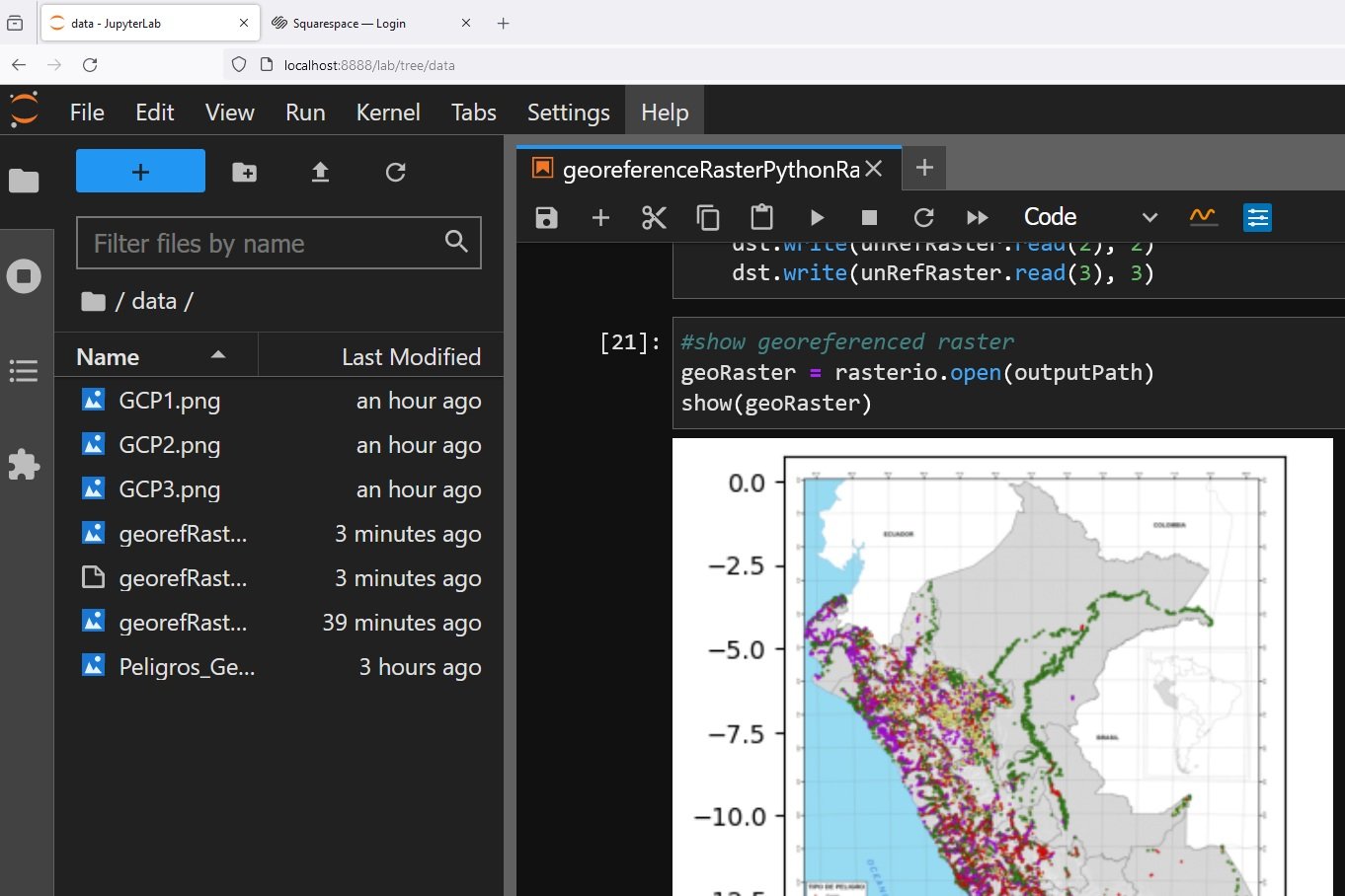
dst.write(unRefRaster.read(3), 3)#show georeferenced raster
geoRaster = rasterio.open(outputPath)
show(geoRaster)