

Development of a watershed-based water balance
/Water balance is known as the balance of water entering the system and the water that leaves within a specified time, but to understand it better we need to understand: what is a watershed? Unterstood as a whole, a unity, as a system, as the space bounded by the union of all the headers that form the main river through the territory drained by a single natural drainage system.
Furthermore, INE-SEMARNAT Pladeyra (2003), assessment of water resources in a watershed requires an accurate water balance (Fig. 1), understanding the cycle at different stages, how the receiving water by precipitation and spread over the process of evapotranspiration, runoff and infiltration.

fig. 1 The hidrologyc cycle
The general objective of developing an integrated and dynamic basin water balance is to determine the current status and future projections of water resources in quantity and quality, setting pressure on it when considering their spatial and temporal distribution of supply, availability and demand, to be a tool to develop guidelines for resource protection, management uses, land use, improve the quality of life of the population and secure investment.
Methodology and theoretical considerations for Water Balance
For the development of water balance, taking into account the general methodology, based on the evaluation and balancing of inputs and outputs at each point or region (Fig. 2) and are described below:

1. Precipitation
The starting point for most water balance studies is the determination of a suitable precipitation series for the watershed. Precipitation data is more widely available than streamflow data and is less affected by land-use changes.
Measurement of Precipitation
Precipitation is the main input to the land-based component of the hydrologic cycle. Accurate calculation of precipitation is an essential input to the water balance, and careful attention must be paid to two areas in particular:
- accuracy of point measurements of precipitation; and
- accuracy of conversion of point measurements to areal measurements over the watershed area.
Procedures for collecting and evaluating data are described in several references (Gray, 1970; Linsley, 1982).
2. Evaporation and Evapotranspiration
Evaporation/evapotranspiration is a collective term for all processes by which water in liquid or solid phase, at or near the earth’s surface, becomes atmospheric water vapour. The term includes evaporation of liquid water from rivers and lakes, bare soil and vegetative surfaces.
Evapotranspiration is the loss of water from soil and plant surfaces. The latter is one of the least understood aspects of the hydrologic cycle.
In general, procedures to estimate evaporation or evapotranspiration on a watershed basis rely, firstly, on an estimate of a potential E and ET (PE and PET), based on meteorological factors, and then conversion of the potential to an actual value for the watershed.
PE and PET values can often be transferred some distance with only minimal error. For hydrologic application, transfers using regional information or calibrated data from adjacent watersheds is often necessary since the relevant data is frequently not available for the watershed under investigation (Singh, 1982).
Actual E and ET are then estimated using PE and PET considering the available moisture supply for each component of a watershed (type of surface, vegetation, soil, availability of water energy supply, etc.).
Table 1 shows how the various types of evapotranspiration estimation methods are distinguished in compliance with the above conditions.

Table 1. Classification of Types of Evapotranspiration
The water balance approach involves applying the water balance equation to a given water body over a time period Dt, and solving that equation for evaporation E, as follows (units are depth or volume per Dt):
ET = P + Qin + Gin – Qout - Gout ± DS (Fig. 3)
where:
P = precipitation;
Qin = surface inflow;
Qout = surface outflow;
Gin = groundwater inflow;
Gout = groundwater outflow; and
DS = change in storage over Dt.

Fig. 3: Water Balance Schematic.
3. Net Uptake
The net inflow is the result of subtraction of the total uptake minus the ETP, this value is then divided by the water that infiltrates and draining according to the model.
4. Infiltration
Is the volume of water from rainfall through the surface of the ground and wholy or partially occupies the pores of the soil and subsoil.
This is calculated after subtracting the evapotranspiration gross uptake, weighing the environmental variables that influence the infiltration capacity or rates of diffusion present in the basin depending on the type of soils and rocks the steepness of the slopes and the type of vegetation and land use.
5. Surface runoff or flow
The rainwater that is not evaporated or infiltrated surface runoff in the form of:
- Runoff water is delivered directly to surface channels in a short period of time after precipitation, and that includes surface runoff and subsurface.
- Runoff is the baseline that feeds the shallow channels in the dry season.
Modelling Model
The SWAT Model
The SWAT (Soil and Water Assessment Tool) is a river basin, or watershed, scale model developed by Dr. Jeff Arnold (1998) for USDA Agricultural Research Service (ARS). The model is the modification of the SWRRB model for application to large basins (Arnold et al., 1990). The model was used with success in several basins worldwide, primarily in United States and innmany European countries, like the Motueka basin (2075 km²) in New Zelande (Cao et al., 2003), the Alban Hills basin (1000 km²) in Central Italia (Benedini et al., 2003), the Celone Creek basin (24072 km²) in Italia (Papagello et al., 2003), and others.
The SWAT simulation tool was developed to simulate the effect of alternative management decisions on water, sediment, and chemical yields with reasonable accuracy for ungaged basins. This is the most complete and used model (Arnold et al., 1998; Neitsch et al., 1999; Neitsch et al., 2001 ; Neitsch et al., 2002).
This agrohydrological model was firstly used by Arnold in 1994 (Arnold et al., 1998), and it is in continual development and enhancement. Hence, there are several available versions of SWAT, such as SWAT992, running under Windows.
SWAT is a comprehensive model that requires a diversity of information in order to run. This information, organized into database, is related to hydrology, weather, sedimentation, soil temperature, crop growth, nutrients, pesticides, ground water and lateral flow, and agricultural management.
The hydrological cycle simulated by SWAT model is based on the water balance equation (Neitsch et al., 2002):
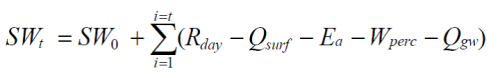
where SWt , SW0 are, respectively, final and initial soil water content (mm/d) ; t is the time (day) ;Rday is the precipitation (mm/d) ; Qsurf is the runoff (mm/d) ; Ea is the evapotranspiration (mm/d) ; Wperc is the percolation (mm/d) ; Qgw is the return flow (mm/d).
SWAT operates on a daily time step and requires the use of, if available, daily rainfall data and maximum and minimum air temperature. If not, they are generated by the model. The precipitation simulation model developed by Nicks (1974) is a first order Markov chain model. Solar radiation, wind speed and relative humidity are always simulated. The SWAT model simulates surface runoff by using the SCS curve number technique (USDA-SCS, 1972).
Three methods are recommended by the model for estimating potential evapotranspiration: Penman-Monteith (Monteith, 1965), Hargreaves and Samani (1985), and Priestley-Taylor (1972). The Penman-Monteith method requires as input, solar radiation, air temperature and relative humidity. The Priestley-Taylor method requires solar radiation and air temperature, while the Hargreaves method requires only air temperature.
The hydraulic structures integration within the hydrosystem, such as reservoirs, are carried out by the reservoir daily water balance equation (Neitsch et al., 2002) :

where V is the volume of water in the reservoir at the end of the day (m3), Vstored is the volume of water stored in the reservoir at the beginning of the day (m3), Vflowin is the daily volume of water entering the reservoir (m3), Vflowout is the daily volume of water flowing out of the reservoir (m3),Vpcp is the daily volume of precipitation falling on the reservoir (m3), Vevap is the daily volume of water removed from the reservoir by evaporation (m3), and Vseep is the daily volume of water lost from the reservoir by seepage (m3).
The flowing volume represents the water supply, such as domestic demand, industry and irrigation needs.
References
- Arnold, J.G., Williams, J.R., Nicks, A.D. & Sammons, N.B., SWRRB-A basin scale simulation model for soil and water resources management, Texas A&M Press. College Station, TX., 1990, 255 p.
- Arnold, J. G., Williams, J. R., Srinivason R. & King, K. W., SWAT : Soil and Water Assessment Tools, USDA, ARS 1998, 92p.
- Benedini, E., Commellozzi, F.& Martinelli, A., “ Model SWAT application in the Alban Hills (central Italy)”, 2ème conférence internationale de SWAT à Bari (Italie) 1-4 juillet 2003.
- Cao, W., Boaden, W. B., Davie, T.& Fenemor, A., “Application of SWAT in large mountainous catchment with high spatial variability”, 2ème conference internationale de SWAT à Bari (Italie) 1-4 juillet 2003.
- Garcia, I; Martinez, A &Vidriales, G., Delimitación De Zonas Prioritarias Y Evaluación De Los Mecanismos Existentes Para Pago De Servicios Ambientales Hidrológicos En La Cuenca Del Río Pixquiac, Veracruz, México.
- Hargreaves, G.H., Samani, Z.A., “Reference crop evapotranspiration from temperature” Applied Engr. Agric. 1, 1985, pp. 96-99.
- Nicks, A. D., “Stochastic generation of the occurrence, pattern, and location of maximum amount of daily rainfall” In Proc. Symp. Statistical Hydrology, Tucson, AZ, USDA Misc. Pub. No. 1275, US Gov. Print. Office, Washington, DC, 1974, pp.154-171.
- Neitsch, S. L., Arnold, J. G. & Williams, J. R., Soil and Water Assessment Tools : user’s manual version 99.2 , Grassland, Soil and Water Reasearch Laboratory, ARS, octobre 1999, 185 p.
- Neitsch, S. L., Arnold, J. G., Kiniry, J. R., Williams, J. R.& King, K. W., Soil and Water Assessment Tools : theoretical documentation version 2000, Grassland, Soil and Water Reasearch Laboratory, ARS, 2002, 91p.
- Neitsch, S. L., Arnold, J. G., Kiniry, J. R. & Williams, J. R., Soil and Water Assessment Tools : user’s manual version 2000, Grassland, Soil and Water Reasearch Laboratory, ARS, 2001, 781p.
- Papagallo, G., Lo Porto, A. & Leone, A., “Use of the SWAT model for evaluation of anthropic impacts on water resource quality and availability in the Celone Creek basin (Aupilia Italy)”, 2ème conférence internationale de SWAT à Bari (Italie) 1-4 juillet 2003.
- Priestley, C.H.B. & Taylor, R.J., “On the assessment of surface heat flux and evaporation using large-scale parameters” Mon. Weather Rev., 100, 1972, pp. 81-92.
- Sokolov, A & Chapman, T., Métodos de cálculo del balance hídrico. Guia internacional de investigación y métodos. Instituto de Hidrologia de España. 1981.
- Torrico, M., Determinación de Balances Hídricos en Microcuencas y Subcuencas. Agencia Sueca de Cooperación Internacional para el Desarrollo. 2011.
- US Department of Agriculture, Soil Conservation Service (USDA-SCS), National Engineering Handbook, Hydrology section, 1972, Chapters 4-10.


