

Land cover spectral signatures determination with QGIS 3 and Semi-Automatic Classification Plugin (SCP 6) - Tutorial
/
The spectral signatures are generated using the bands presented by the image. It is defined as a response pattern that is characteristic since each material in nature has its own interaction with electromagnetic energy. The basis of a classification is to find some areas of the electromagnetic spectrum in which the nature of this interaction is different for the materials within the image.
We understand by spectral signature as the reflectance as a function of the wavelength. The spectral signatures are used by classification algorithms that allow to label the pixels of the image. Different materials can have similar spectral signatures (construction, water, bare soils and vegetation cover).
In the following image it is observed that each material has a unique signature, therefore, this spectral signature can be used for the classification of materials such as land cover, vegetation, water and asphalt / construction, depending on the resolution of the sensor, number and type of coverages that can be identified.

Semi-automatic Classification plugin
In this tutorial we will perform the evaluation of spectral signatures using the Semi-automatic Classification complement in version 6, which is a free open source plugin for QGIS 3 that allows the supervised and unsupervised classification of remote sensing images. It also provides the following utilities:
- Download free images (Landsat, Sentinel-2, Sentinel-3, ASTER and MODIS).
- Preprocessing of satellite images.
- Postprocessing of classifications.
- Raster calculation.

Semi-Automatic Classification plug-in interface (Version 6) compatible with QGIS 3
There are several satellites with different characteristics that acquire multispectral images of the surface of the earth. In this case, the Sentinel 2 images are particularly useful for the monitoring of land cover and can be provided free of charge from SCP.
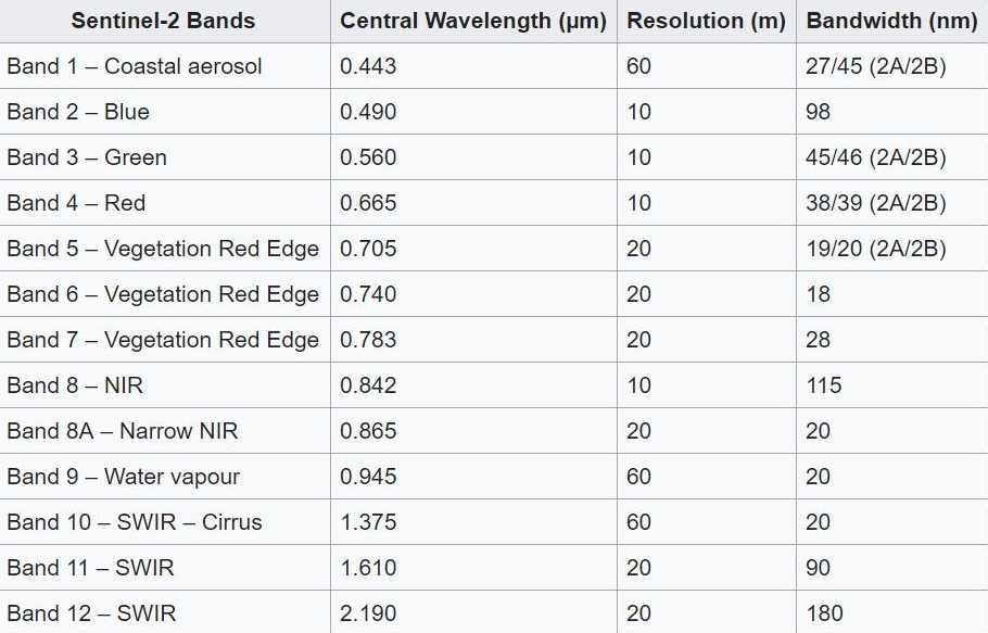
Resolution and wavelength of the Sentinel spectral bands -2
Sentinel-2 images are available for free on the ESA website https://scihub.copernicus.eu
Tutorial
For this tutorial, the analysis of the spectral signatures will be carried out based on the classification coverages:
- Water
- Buildings
- Vegetation
- Naked soil
Video tutorial
Spectral signature analysis
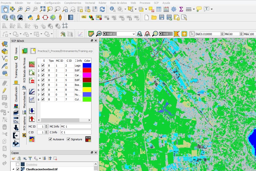
The spectral signatures (spectral characteristics) of the land cover classes are calculated taking into account the pixel values below each ROI. ROIs are polygons used for the definition of spectral signatures characteristic of land cover classes.
Therefore, the algorithm classifies the complete image by comparing the spectral characteristics of each pixel with the spectral characteristics of the terrestrial coverage classes of reference. Next we will determine the behavior of the spectral signatures of lakes, vegetation, non-vegetated soils and construction:
Behavior of the spectral signature of Lagos
The amount of reflected radiation with respect to the wavelength is observed, where the response of the spectral signature is reduced towards the infrared, this behavior is typical in lacustrine bodies since the increase in the depth of the bodies of water decreases the reflectance at any wavelength.

Behavior of vegetation spectral signature
In the case of vegetation, it is a resource that depends on many characteristics depending on the type of species to be evaluated (leaves, stems, trunk, humidity, etc.), considering that this coverage is subject to different environmental changes. In this tutorial we are evaluating deciduous forest crops (trees), where the reflectance is low in the visible with an increase in the green color due to the presence of chlorophyll that is characteristic of the leaves. The reflectance increases in the near infrared due to the scarce absorption of energy by plants. In the mid-infrared, there is a significant decrease along the wavelengths, since the water in the plant absorbs the energy.

Behavior of the spectral signature of dry soils
In the case of uncultivated (dry) soils, it is observed that the spectral signature presents a different behavior compared to the spectral signature of the crop coverage, the peak in the green color of the visible zone is no longer visible and there is a increase in reflectance along wavelengths since plants no longer absorb water.

Behavior of the construction spectral signature
The spectral behavior depends on several characteristics such as air and water content, granulometric structure and texture. In this case, when dealing with construction covers such as buildings and roads, they are smooth surfaces that implies that the reflectance increases along the wavelength.


